Our Annapurna Circuit Trek is one of the most popular yet challenging treks that is done inside the famous Annapurna region of Nepal. Located far away from the city areas, the entire trek route of Annapurna Circuit Trek follows distinct, serene trails filled with charming ethnic village communities, dazzling arrays of Himalayan scenery and huge abundance of pristine nature and emotive cultural norms. However, it is still a long, arduous journey that will take at least 19 days to complete but is sure to be a worthwhile journey that will leave a great impression on your heart and soul, no matter what.
The first day of our trek begins with your arrival to Kathmandu city where you will visit and explore some of the most enriching places including UNESCO World Heritage Sites like Boudhanath, Swayambhunath, Pashupatinath and Kathmandu Durbar Square. Each of these places have their own unique history and significance for the Nepalese people who follow and recognize the value of these heritages passed on to them from their ancestors. After that, we drive off to Besisahar- a small western town, where we shall start our trekking adventure for the upcoming days. And before calling it a day, we will need to trek up to Syange village (1100m).
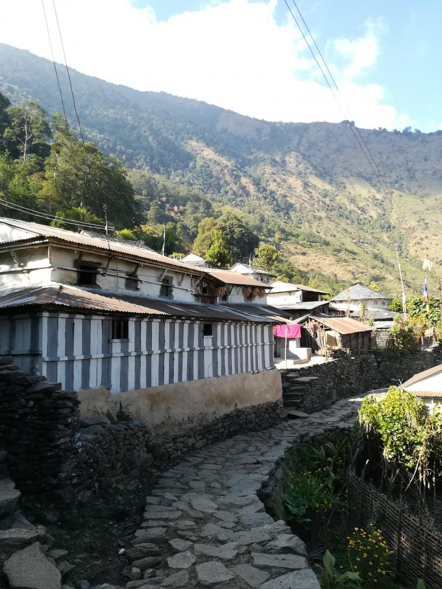
From Syange, the trail becomes rough and stony but the whole atmosphere will be filled with an aura of natural beauty and cultural harmony. While it may sound perplexing to some, but it’s always a good idea to take it slow and not to hurry while trekking as you might miss out on some great things while hurrying on your way to your next destination for the night. Slowly, we head higher and higher and ultimately reach Manang village (3540m). This village is a suitable place for acclimatization and letting our bodies rest, while exploring some of the near by sites like Gangapurna lake and Melarepa Cave.
Now comes the great struggle of crossing the formidable Thorung La Pass which is situated at a very high altitude of 5,416 meters above sea level. And this my friend can get very tough for trekkers who are drained of their energy or aren’t fit enough to do so. But once you get over this pass, a beautiful temple called Muktinath awaits you as there are several lodges and guest houses where you can find a room into rest and relax your exhausted bodies. Later, we shall end our trek by heading to Pokhara from Marpha to Kalopani and so on. But prior to that, we shall visit Ghorepani village & Poonhill for spectacular view of the Annapurna mountain range.
Want to go on our Annapurna Circuit Trek? Then, contact us today and book this trip immediately with us!
| Day | Highlight | Overnight |
|---|---|---|
| Day 1 | Welcome to Kathmandu (1,338m/4,390ft) | Kathmandu |
| Day 2 | Kathmandu sightseeing and trek preparation | Kathmandu |
| Day 3 | Drive from Kathmandu to Besishahar and to Bhulbhule (840m/2,756ft) | Bhulbhule |
| Day 4 | Trek from Bhulbhule to Chamje (1,410m/4,626ft) | Chamje |
| Day 5 | Trek from Chamje to Dharapani (1,960m/6431ft) | Dharapani |
| Day 6 | Trek from Dharapani to Chame (2,630m/8,890ft) | Chame |
| Day 7 | Trek from Chame to Pisang (3,200m/10,824ft) | Pisang |
| Day 8 | Trek from Pisang to Manang (3,540m/11,611ft) | Manang |
| Day 9 | Manang Acclimatization Day (Optional hike to Gangapurna lake or Melarepa cave) | Manang |
| Day 10 | Trek from Manang to Yak Kharka (or you can push up to Letdar) (4,110m/13,484ft) | Yak Kharka |
| Day 11 | Trek from Yak Kharka to Thorang Phedi (4,420m/14,501ft) | Thorang Phedi |
| Day 12 | Trek from Thorong Phedi, cross Thorongla Pass (5,416m/17,769ft) and trek to Muktinath (3,800m/12,467ft) | Muktinath |
| Day 13 | Trek from Muktinath to Marpha (2,660m/8,250ft) | Marpha |
| Day 14 | Trek from Marpha to Kalopani (2,530m/7,848ft) | Kalopani |
| Day 15 | Trek from Kalopani to Tatopani (1,190m/3,690ft) | Tatopani |
| Day 16 | Trek from Tatopani to Ghorepani (2,780m/9,480ft) | Ghorepani |
| Day 17 | Hike from Ghorepani to Poonhill (3,210m/10,531ft), descend to Tadapani (2630m/8626ft) | Tadapani |
| Day 18 | Trek from Tadapani to Ghandruk (1,940m/6,360ft) and drive to Pokhara | Pokhara |
| Day 19 | Drive from Pokhara to Kathmandu | Kathmandu |
| Day 20 | Airport drop and international departure from Kathmandu |
After your arrival at Kathmandu, you will be met by our representative outside the terminal hall of the international airport. Afterward, you will be greeted warmly and escorted to your hotel. You will be introduced to your trekking guide and have an effectual conversation relating your upcoming adventure. At evening you can just stroll around the colorful Thamel Bazaar, a favorite location among tourist visiting the capital city of the country.
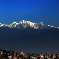
Today after breakfast and a short briefing you will be visiting the Kathmandu city in a private vehicle. Kathmandu, being the heart of the nation carries a significant historical and cultural heritage. The city is populated by the citizens from every corner of the country establishing a common ground for observing different ethnic culture and lifestyle of the people around this Himalayan nation. From ancient times the city has witnessed religious tolerance among the people, as a result, it consists a number of different sites listed in the UNESCO world heritage list that you will be visiting one by one; the sacred Hindu shrine of Pashupatinath, sacred Buddhist shrine Boudhanath and Swayambhunath – located close to Thamel. Your day tour ends at Basantapur Durbar Square Area: listed as UNESCO world heritage that showcases the temple of living goddess Kumari, the Swet Bhairav, the Kaal Bhairav, Freak Street and many more.
After an early breakfast, we will begin a 7-8 hours drive along Kathmandu-Pokhara Highway and head to Besishahar then to Bhulbhule on a private vehicle/ tourist bus. During the journey, we will pass through the forested middle hills, small towns and farming communities located south of the Himalayan highlands. We will also follow the several major rivers flowing along the highway including river Trishuli and Marsyangdi to Dumre and turn north on a narrow and paved secondary road to Besisahar where we will get to witness stunning snow-capped mountain scenery before continuing to Bhulbhule (8,40m).
The trek which takes about 6-7 hours from Bhulbhule to Chamje is considered to be one of its kinds with the phenomenal views of the majestic mountains. Leaving Bhulbhule, we trek on the flat for the first part of the trail and ascend abruptly where the trail cut into precipitous cliff-face at the elevation of 200-300m from the riverbed. Finally, we descend down the trail and reach the stone village of Jagat (1,330m) situated on the ledge which extends into the abrupt Marsyangdi Valley. Then the trail descends, then, climbs to the Tibetan-styled village called Chamje (1,410m) passing through the rocky forest. We can visit the tantalizing waterfall situated there.
Now following the trail we enter the Manang district via crossing the large suspension bridge over river Marsyangdi and begin a steep climb to Sattale (1,550m). We continue the climb on the serpentine path above the river to the top of the hill. From here we can observe the uniform but the graceful plain of Tal, a former lakebed where the lovely village of Tal (1,700m), is located. Further, the trail becomes high and zigzag continuing past the barley, potato and wheat fields. In several areas, the path is cleave from the rock itself accompanied by waterfalls and passing through the pine forest to reach Karte (1,900m). Passing from this small village, we continue the trek to reach Dharapani (1,960m): one of the biggest villages in the Manang valley situated at the conflux of the two rivers.
We begin our day by having some breakfast followed by 6-7 hours of trekking to Chame from Dharapani where En route we are presented with an irresistible sight of Annapurna IV (7,525m), Lamjung Himal (6,893m) and Annapurna II (7,927m). The trek starts from a narrow field along the river Marsyangdi. Then the river swerve left and as Mt. Annapurna II (7,927m) is visible we enter the Bhote village of Bagarchhap where we can behold Buddhist monastery adorned with prayer flags around drifting in the gentle wind around. Then continuing further on the trail, we climb through the woodland of oak and pine and pass through Danaque village (2,210m). Afterwards, crossing a small wooden bridge we follow a sheer ascending path Timang village situated at the bottom of Lumjung Himal and the trail proceeds through a flat level till we reach the village of Chame (2,630m).
With the first rays of the morning sunrise over the Himalayas, we set off to Pisang which takes about 5-6 hours. As we climb up the valley passing by the immense apple orchard, the mountains disappear. We continue through the groove of pine and fir. The opposite bank becomes untraversable cliff as we climb to a high rocky area. Further this point the valley becomes extremely steep as we pursue the path to Bratang village (2,950m). After a short climb from the village, the trail turns the corner and we can see the extraordinary view of Paungda Danda rock face: an enormous curved slab of rock that rises over 1,500m from the river. Now we follow a high and meandering path before crossing back again to the south bank of the river Marsyangdi on a suspension bridge at the elevation of 3,080m. Afterwards, we begin long but gentle climb over an upland passing through the blue pine forest. As the forest ends, the upper Manang valley changes from a V-shape to tender U-shape between two giant peaks revealing sublime panorama. The views become more exciting as we reach to a long Mani wall by a bridge, then to the lower village of Pisang (3,200m).
Today we can follow two routes to reach Manang from Pisang. The upper and more challenging route utilizes about 7-8 hours. It begins from Upper Pisang into the dry Nyesyang district offering some impressive sights en route. Then, we pass through small but delightful clustered village of Ghyaru with nice-looking stone houses surrounded by the fields of crops that can tackle with short growing season i.e. beans, buckwheat, barley, wheat and potatoes. Then we reach a high and long transverse with elegant vista, up and down the valley, to the fascinating village with ancient Juniper trees and gompas: Ngawal. Now the trail gradually descends to Mungji, where a convent is situated above the village. Continuing the journey, we trek to Braga. It is a small Himalayan village which boasts of quaint clustered houses built one above the other, up to a rock-strewn slope with a spectacular gumba at the top. The gumba is the oldest, largest and best endued in the valley. A short walk from Braga will lead us to Manang.
The lower easier route takes about 5-6 hours starting with the steep climb of the upland which provides an excellent outlook of Tilicho peak (7,145m) and Manang valley. We now descend passing by the Manang’s airstrip at Humde (3,320m) which leads to a uniform territory where the north-east flank of Annapurna III (7,555m) arises to the blue and limitless skies atop us. The extensive flatland of the Sabje Khola valley also enables us to view the splendid glimpse of Annapurna IV (7,525m). A few distances further, we wander over wooden bridge extended across the Marsyangdi Khola to the small but elegant village of Mungji. Off the right and on both sides of the trail we can observe cultivated farmland which indicates the presence of human settlements. Below the ragged mountaintop, we can visualize the exquisite village of Bagra with its magnificent monastery being largest in the district which harbours marvellous display of statues. Here in the village, we get to see houses stacked one on top of the other, each with an open veranda that provides rooftop for the adjoining house. We can continue with the parched landscapes alongside the trail that is dominated by bizarre cliffs of yellow rock that have been shaped into startling pillars by years of erosion. After a short steep climb, we will reach Manang.
We spend the day acclimatizing in the thinner air at higher elevations by doing some walks and sightseeing around the village. We can visit the little cultural museum located in the centre of the village. The museum is a treasure chest containing locally collected artefacts that demonstrate the traditional way of life that has hardly changed over the generations. Also, the optional day walks as climbing high above the village to observe bird’s-eye view of the Annapurna range and Manang valley or crossing the river to watch the immense icefall advancing down from the Annapurna. There is an optional hike to Gangapurna lake or Melarepa cave to create an indelible memory in our minds. However, it is important to have a day full of rest to allow our body to acclimatize to thinning air and the higher altitudes. Also, there is the mandatory visit to Himalayan Rescue Association (HRA) aid post in the village for educational but interesting information like Altitude Mountain Sickness and its symptoms.
Today we start our trek following the trail that crosses a stream and then climbs to the village of Tengi. Swinging up northwest up the valley of Jarsang Khola, we continue the climb out of the Marsyangdi Valley. The trail continually attains elevation as it passes by some summer pastureland and Scrub juniper. It then ascends above Gunsang village (3,960m) and extends to the small town of Ghyanchang (3,996m) where it plummets across a side stream. The trail now continues to arise through pieces of grassland used for grazing of yaks and horses. After making one’s way across the small wooden bridge, we climb to an ancient Mani wall then to Yak Kharka (4,110m). It takes about 3-4 hours to reach this idyllic village. The word ‘Yak’ refers to long-haired, domesticated, short-legged oxlike mammal found in the Himalayan region and ‘Kharka’ means meadows or pasture. We can catch heavenly sights all day en route. It seems to be a short hike, yet, as we climb higher elevation containing less oxygen we feel tired early compared to normal times. A slow gradual ascent is essential to avoid altitude sickness. After passing Yak Kharka you can push up to Letdar (4,260m) which takes about an hour to reach.
As we cross the yak pastures, we start our trek with a gradual climb to upland before crossing a wooden bridge to passing down to the source of river Marsyangdi. We lose the rivers behind as we ascend into quiet alpine areas. The vista is completely different and the mountain views are heavenly. Across a constrict trail across an unsteady spree downslope, we now follow a constrict trail descending to Thorang Phedi (4,420m). It utilizes 3-4 hours to reach today’s end destination. It is another easy and short day to become accustomed to thin air and high altitude before crossing the highest point in the trek, and probably the highest point we have ever conquered in our very life.
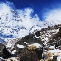
Quite early in the morning, we start the longest and most challenging trek of our entire adventure (around 8-10 hours) by crossing the Thorong La Pass (5,416m) which is one of the trek’s highlight. The trail becomes steep immediately. Crossing it is a lifetime memorable experience, demanding a nearly 1000m ascent and 1600m descent respectively. Thorong La is the mountain pass between Thorung Peak (6,211m/20,378ft) and the majestic cliffs of Yakwakang (6,482m/15,434ft). From the summit adorned with the flag, to the west is the magnificent barren brown vista down into the arid region of Mustang valley/Kali Gandaki a great distance below. To the east is alluring snowscape. The enormous Dhauligiri range can be located on the opposite side of the valley and the Dolpo stretch (an extension of the Tibetan highlands) on the northern horizon. For centuries, local people have used this trail bringing their sheep and yaks in and out of Manang so the trail is well defined. We must pass the cross the pass around 9 or 10 am as the wind gets up later. After a little sight-seeing and capturing the divine panorama on the summit. Now we begin a knee pulverizing descend to 1,600m but still its worth, as we will be greeted by the ravishing sight of Dhaulagiri at the distance across the valley. As the trail becomes less abrupt we eventually enter the meadows and grasslands to Muktinath. Legends explain this place as a site where your soul gets deliverance from intense and selfish desires of this world to eternal peace. The area is home to a temple and several monasteries. This is a sacred pilgrimage site to both Hindus and Buddhist: a testament to the mutual religious harmony in Nepal. The Temple is dedicated to Lord Vishnu and from here spring water flows from a rock face from 108 spouts (108 is a sacred number to Buddhists). Jwala Mai Temple with a gorgeous natural spring alongside an eternal flame fueled by natural gas is also situated here. Also, shrines devoted to Lord Shiva and his consort and Padmasambhava is must see place.
Through the parched area in the same geographical and climate zone as Tibet; we now descent down remarkable Kali Gandaki gorge. Then, we pass through Jharkot, Khingar and Kagbeni villages respectively, which showcases typical Tibetan architecture. Kagbeni is famous for a monastery which is believed to be dated back to the 15th century. Further, the very village shares its northern borderline with upper Mustang. From here, we follow the trail to Jomsom, the major town with an operational airport. Then we trek up to Marpha village (2,660m). The village of Marpha is enriched with its own culture and a Buddhist monastery. It is prominent for its apple cultivation and huge apple orchards. The most celebrated ‘Marpha’: an apple brandy, has its roots connected to Marpha region as it is fermented and distilled only in this specific region.
Leaving Marpha, we descend through the valley and trek along the Kali Gandaki River. This trail is stretched at almost flat level up to Kalopani En route; we will have the moment to get a peek on the elegant Annapurna I and beautiful landscapes. It takes about 6-7 hours to reach Kalopani (2,530m).
Today we descend steeply through the forest to Ghasa. Rhododendron and pine forests cover the first part of the trek through the gusty area. Ghasa with its surrounding area is famous for bird watching and wild Marijuana. From here, we trek through the trail that descends steeply up to Rupse Chhahara (waterfall). The deepest gorge in the world is situated between two massif Annapurna I (8,091m) in east and Dhaulagiri I (8,167m) in the west facing each near this very waterfall. Now, through different settlements, the trail slightly ascends to Tatopani (1,190m) that takes about 6-7 hours of a hike to complete.
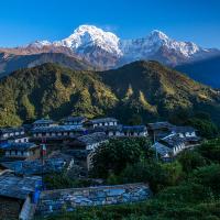
Swinging south-east to the front of the Annapurna range, we climb abruptly up the Ghar Khola Valley; once we left Tatopani. The trail passes through forest majorly inhabited by bird and monkeys and comprises of oak, rhododendron, birch and magnolia and continues through the villages such as Ghara, Phalate and Chitre are arid on high uplands with great views north to the Annapurnas or back towards Dhaulagiri. These villages are inhabited by the people of different castes and a perfect harmony can be observed. Then, the trail gently ascends all the way to Ghorepani (2,780m). This beautiful village is majorly populated by Gurung people who are very generous and friendly to new and unknown people. Majority of the men in this and surrounding village had served the British and Indian army and the pension along with agriculture and tourism and hospitality business has made this area prosperous. We are warmly escorted by the angelic sight of different mountains. The trek takes about 6-7 hours to complete.
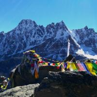
Early in the morning we hike for an hour to Poonhill from Ghorepani to view and enjoy the alluring sunrise glimpse over the Himalayas including the mountains like Annapurna III (7,855m), Machhapuchhre (6,993m), Annapurna IV (7,525m), Annapurna II (7,937m), Lamjung Himal (6,931m), Mt. Dhaulagiri (8,167m), Tukuche Peak (6,920m), Nilgiri (6,940m), Varaha Shikhar (7,847m), Mt. Annapurna I (8,091m), Annapurna South (7,219m) and other various snowcapped mountain peaks. Afterwards, we return to Ghorepani again and move down the trail for about 5-6 hours to Tadapani (2,630m). En route we will be accompanied by the delightful display of the mountains ranges like Annapurna and Macchapuchre mountain ranges.
Today we will have short, pleasant and largely downhill hike which utilizes about 3-4 hours to complete. With the admiring sight of the snow-capped mountains: the trail passes through various farmlands and forest to the heavenly village of Ghandruk (1,940m), a densely populated, modern, clean Gurung village which boasts of its own ethnic culture and lifestyle. The lovely sight of Annapurna South, Machhapuchhre Range and Hiunchuli mountains steals the heart and conciseness at the very moment enabling us to forget the pain and struggles we had endured from the beginning of the whole adventure. When we are not just simply relaxing, it is worth exploring the surrounding area, interacting with the friendly locale and visiting the museum. Exchanging farewells with the friendly locale we will walk for about 45 mins and arrive at Kimche. Now we drive from Kimche to Pokhara which takes about 1 hour on a private vehicle.
Today you are heading to Kathmandu on a private vehicle/tourist bus. The drive on the Prithvi Highway from Pokhara takes about 5-6 hours depending upon traffic conditions. It will be a worthwhile drive as you get the opportunity to observe the natural scenery and lifestyle of the people superficially as we pass along many satellite towns on the way to Kathmandu. Once in Kathmandu; you’ll be transferred to your hotel. You can spend the rest of the day relaxing and enjoying hotel facilities or just wander around the city.
We are honoured to be with you in every wonderful moment during your stay in Nepal. We hope that you have enjoyed your stay and visit accompanied by us. We sincerely believe that our relationship can develop into a long and warm friendship. Therefore, on your last day in the country, one of our representatives will accompany you to the airport. Safe flight back home!!! Adios!!!

-1200x1200.jpg)


This is the short version of the Annapur
The daunting experience of landing on th
Trekking can be a very addictive adventu
The scenic views of the Himalayas have a
Nepal, famously known as the land of the
The journey starts from the capital stra


